
Key Facts
- New York City’s travel advisory begins at 2 p.m. EDT Friday, Sept. 25, and runs through Sunday morning, Sept. 27.
- City officials forecast 2 to 3 inches of rain citywide, with locally higher totals possible. The National Weather Service says the storm’s track could still shift the areas of heaviest rainfall.nyc+1
- Wind gusts of 40 to 50 mph are expected, especially Friday night through Saturday night. A National Weather Service wind advisory covers New York City from 2 p.m. Friday to 6 a.m. Sunday.
- Coastal flooding is a particular concern around the Friday evening and Saturday morning high tides, including in the Rockaways, around Jamaica Bay, and along parts of the Brooklyn and Staten Island shorelines.
- Residents of basement or ground-floor homes in flood-prone areas should know how to reach higher ground. Drivers should move vehicles from streets that routinely flood before high tide.
- City beaches are closed for the season and have no lifeguards. Dangerous surf and a high risk of rip currents are expected through at least Saturday.
NEW YORK — New Yorkers should prepare Friday for a prolonged nor’easter that could bring strong winds, heavy rain and coastal flooding through the weekend, with the greatest coastal threat expected around Friday evening and Saturday morning high tides.
Mayor Zohran Mamdani and New York City Emergency Management issued a travel advisory beginning at 2 p.m. Friday. Their forecast calls for 2 to 3 inches of rain across the city and gusts of 40 to 50 mph. The National Weather Service’s New York office said in a 5:10 a.m. Friday forecast discussion that the storm’s rain and wind could continue into Sunday, while conditions near the coast may take longer to improve. These are forecasts, not rainfall or wind totals already observed.
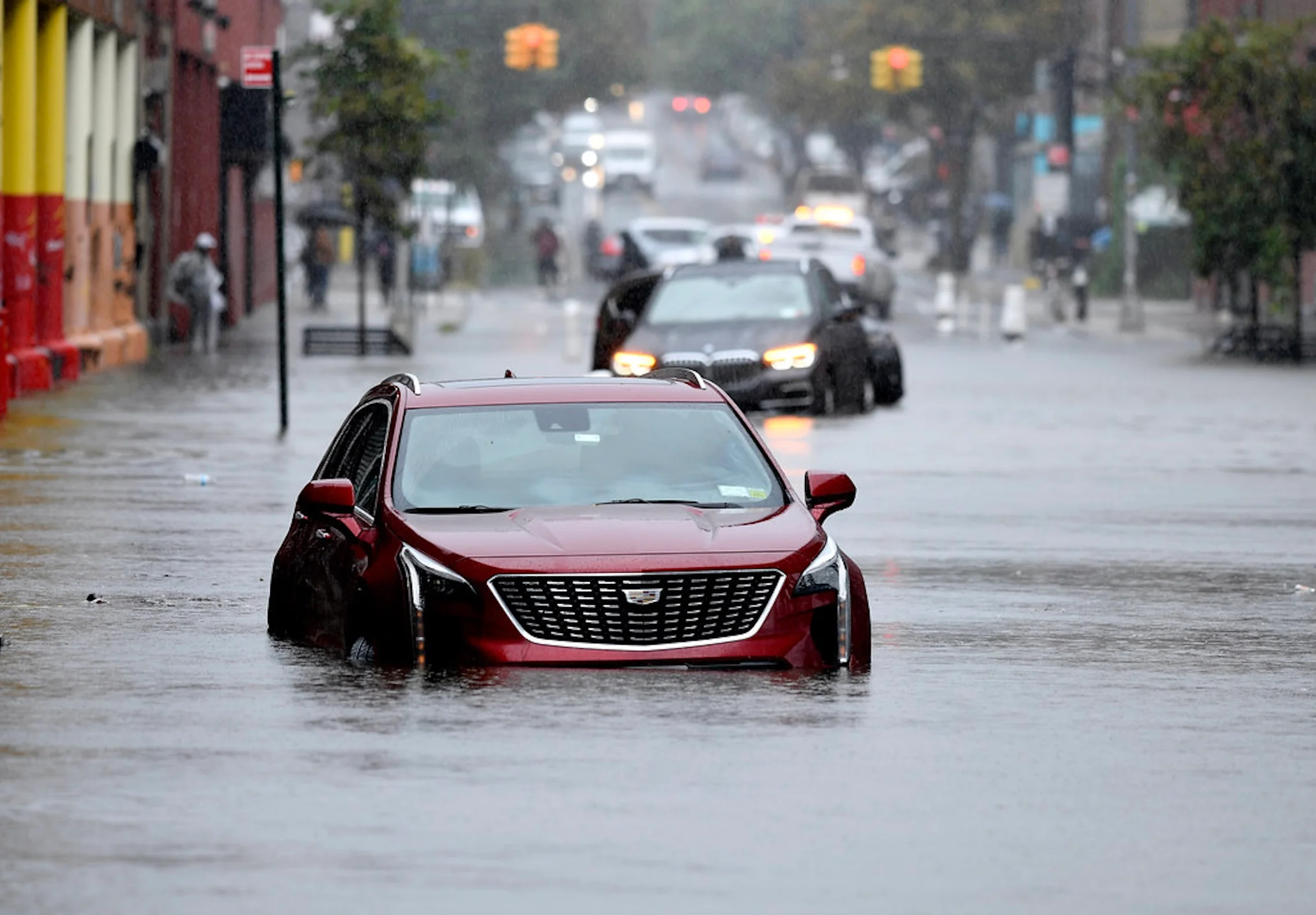
The immediate preparation is straightforward: secure loose outdoor items, charge essential devices, check travel plans and avoid flood-prone waterfront roads around high tide. People living in basement apartments face a more urgent decision. They should identify an exit and be ready to move to a higher floor if water threatens their home.
What the latest forecast shows
The storm’s projected path moved closer to New York City on Thursday, prompting officials to raise the citywide rainfall forecast from roughly 1 to 1.5 inches to 2 to 3 inches. The city said isolated locations could receive 4 to 5 inches if bands of heavier rain repeatedly pass over the same area, particularly if the storm tracks farther west. That higher figure is a possibility, not the general forecast.
The National Weather Service expects rain to spread across the region Friday and become moderate to heavy at times Friday night through Saturday night. Its Friday morning outlook projected 1 to 3 inches for much of the wider forecast area, with 3 to 4 inches in central and eastern Long Island. Forecasters cautioned that the location of the heaviest rain could change with the storm track.
Widespread flash flooding was not expected in the city’s Thursday advisory, although isolated flash flooding could not be ruled out. Roadways, underpasses and places with poor drainage may still flood. Residents should not interpret a lower regionwide flash-flood risk as assurance that a particular block, basement or underpass will remain dry.
Northerly and northeasterly winds are expected to build Friday, with the strongest gusts Friday night through Saturday night. The National Weather Service said localized gusts could approach 55 mph, with the highest gusts most likely near exposed Long Island shorelines. It also expanded its wind advisory across much of the surrounding region, including southern Connecticut, Westchester and Rockland counties and most of northeast New Jersey.
The combination of wind and wet ground raises the risk of falling branches, downed power lines and outages. Trees still carry leaves in September, giving strong winds more surface to push against. That is a reason to prepare for an interruption, not a prediction that any particular neighborhood will lose power.
When coastal flooding is most likely
New York City officials identified two high-tide periods to watch: approximately 7:30 to 8:30 p.m. Friday and 7:30 to 8:40 a.m. Saturday, depending on location. Water may also cause minor flooding at later high tides.
The Rockaways and Jamaica Bay in southern Queens face a risk of moderate coastal flooding, as do portions of the Staten Island and Brooklyn shorelines, the city said. Minor to moderate flooding is possible around Flushing Bay, with minor flooding expected near the Battery. The National Weather Service also highlighted southern New York City and Long Island for potentially greater impacts Friday night into Saturday morning.nyc+1
A coastal flood watch signals the possibility of flooding; it does not mean every shoreline will experience the same water level. Conditions vary by location and may change as forecasters refine the expected track and surge. Residents should check alerts for their specific address rather than rely on a citywide forecast alone.
How to prepare before conditions worsen
For people in flood-prone neighborhoods, the safest time to move a vehicle or change a travel plan is before water reaches the street. City emergency officials recommend moving cars parked in areas that regularly flood to higher ground ahead of high tide. They also advise never walking or driving through floodwater or around a traffic barricade.
Basement and ground-floor residents in low-lying areas should identify more than one way out and decide where they could go on a higher floor if conditions deteriorate. Do not remain in, or re-enter a flooded basement. Floodwater can make exits difficult to use, while electrical equipment may create additional danger.
Other useful preparations include:
- Bring in or secure balcony furniture, grills, planters, garbage cans and other objects that strong gusts could move.
- Charge phones and essential equipment. Anyone who relies on electrically powered medical devices should check backup batteries and their utility provider’s emergency procedures.
- Allow extra travel time and check train, ferry and flight status before leaving. A travel advisory warns of possible disruption; it is not an announcement that all services have stopped.
- Stay clear of trees, power lines, scaffolding and construction sites during strong winds.
- Check on neighbors who may need assistance, particularly older adults, people with disabilities and residents of low-lying homes.
New York City has activated its Flash Flood Emergency Plan and said agencies are clearing catch basins, preparing for downed trees and positioning resources in areas at risk of coastal flooding. Those measures do not eliminate household-level risk, especially where water can enter below street level.
Beaches and waterfront travel
Residents should stay out of the surf. The National Weather Service expects high surf, beach erosion and a high risk of rip currents along ocean-facing shores through at least Saturday. New York City beaches closed for the season on Sept. 13; lifeguards are no longer on duty, and swimming is not permitted.
The weather service forecast surf of roughly 7 to 11 feet near shore, though conditions will vary by beach. Higher waves forecast for offshore waters should not be confused with wave heights at every city beach. People should keep a safe distance from waves, seawalls and jetties rather than approaching them for photographs.
The forecast also gives travelers reason to monitor airports and coastal transport. National Weather Service aviation guidance identifies a potential for reduced visibility and strong gusts Friday night into Saturday. It does not establish which individual flight, ferry or train will be delayed. Check directly with the operator before traveling.
What remains uncertain
The nor’easter’s exact track remains consequential. A shift could change where the heaviest rain falls, which neighborhoods see the strongest gusts and how high coastal water rises. The National Weather Service’s Friday morning discussion placed particular emphasis on Long Island and southern New York City for coastal flooding, while the city’s advisory identified specific vulnerable waterfront areas across the five boroughs.
There is no need to wait for certainty before taking low-cost precautions. Securing loose items and charging a phone are sensible even if conditions ultimately prove less severe at a particular address. More consequential choices, such as changing plans or leaving a vulnerable home, should be guided by official alerts and conditions on the ground.
New Yorkers can receive city emergency updates through Notify NYC by texting NOTIFYNYC to 692-692. The city says residents of basement apartments can also sign up for automated flooding alerts. Call 911 for immediate danger and 311 for nonemergency city issues.
The next forecast updates will be especially important before Friday evening’s high tide and again before Saturday morning’s. This report reflects the city’s Sept. 24 advisory and the National Weather Service discussion issued at 5:10 a.m. EDT Sept. 25; readers should check current warnings before making travel or safety decisions.