
Google has brought its long‑hidden Google Earth Flight Simulator into the browser age, turning its global 3D maps into a free, lightweight flying experience that lets anyone “pilot” an aircraft over real‑world terrain with just a keyboard, mouse and web connection.
From hidden Easter egg to browser toy
Google first added a flight simulator mode to Google Earth as a tucked‑away feature in its desktop app more than a decade ago, letting users choose a light aircraft or fighter jet and fly over satellite imagery.
For years, that mode required downloading Google Earth for Windows, Mac or Linux and digging into the Tools menu or pressing a keyboard shortcut to “Enter Flight Simulator.”
Now, Google has introduced an experimental flight simulator directly inside Google Earth on the web, making the feature globally available through a browser without any install.
You launch it by opening Google Earth, clicking “Explore Earth” on the home screen, then selecting “Flight Simulator” under the Tools menu, turning the familiar globe into a live cockpit view in a few clicks.
How to launch and control your flight
On desktop, Google Earth’s own help documentation describes two core steps: open Earth, then start the simulator via Tools → Flight Simulator or a keyboard shortcut.
Once in the cockpit, you can pick your starting point, either from your current view or from a list of major airports, and choose basic control options like mouse plus keyboard or joystick.
The in‑browser version leans on simple key commands: Page Up and Page Down control thrust, while the arrow keys handle pitch and roll.
Clicking inside the simulation toggles mouse controls on or off, allowing casual pilots to steer with small mouse movements and nudge the plane with arrow keys for finer corrections.
For users on the older desktop variant, Google still lists a slightly different set of shortcuts, including Ctrl+Alt+A (or ⌘+Option+A on Mac) to enter or exit, and recommends the SR22 for beginners and the F‑16 for more advanced virtual pilots.
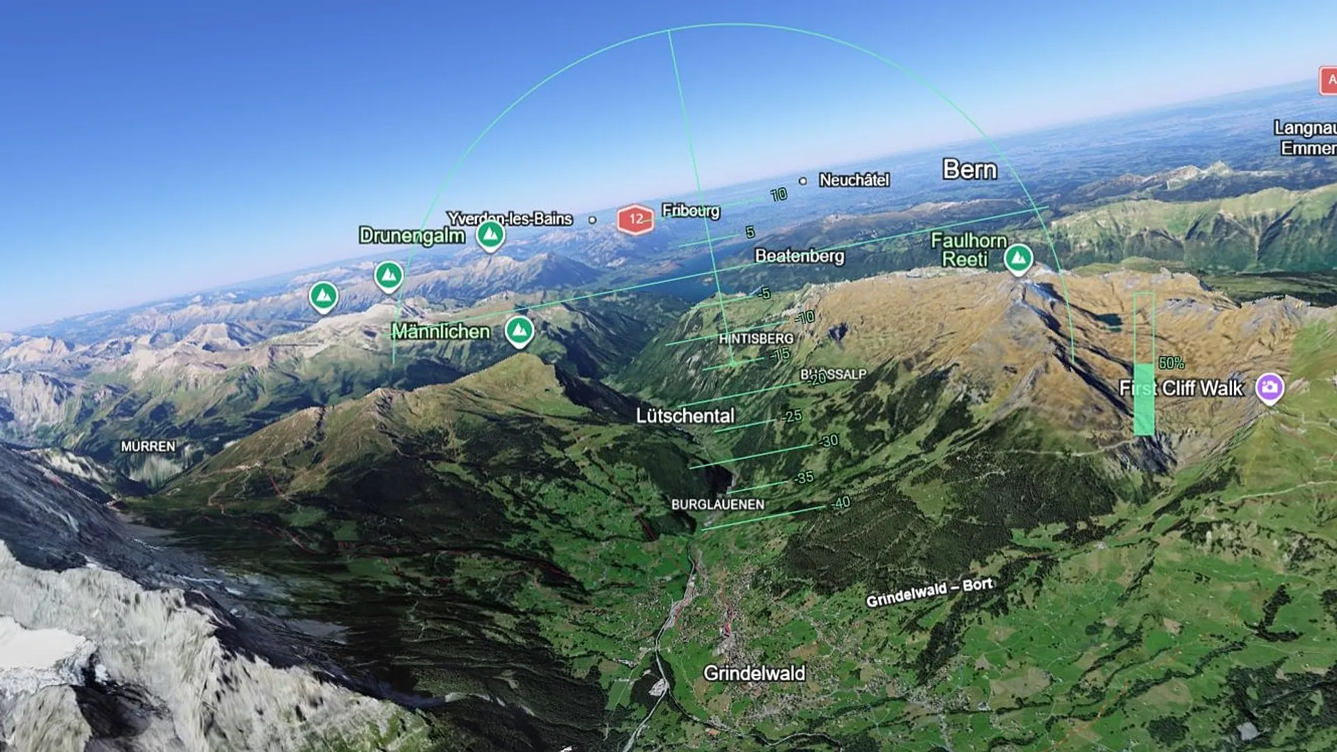
A built‑in head‑up display shows speed, altitude and heading, and pressing a help key such as Ctrl+H overlays an instructions panel, mirroring the minimal cockpit feel of classic consumer sims.
What it’s like inside Google Earth Flight Simulator
Unlike high‑fidelity simulators that model complex aerodynamics, Google Earth’s Flight Simulator is designed for “casual exploration rather than high‑fidelity aerodynamic training,” as Google explicitly tells users.
The experience relies on Earth’s existing aerial and satellite imagery, along with 3D building data in many cities, so flying over a place like New York, Tokyo or the Alps feels like skimming a textured, photo‑real landscape rather than a game‑engine world.
You start at a safe altitude or on the runway, push thrust up, and gradually climb, watching real‑world coastlines, road grids and mountain ranges slide beneath your wings.
Crash detection is deliberately forgiving: if you stall or hit terrain, the sim pauses and offers a quick “You crashed! Restart” option to put the plane back at a playable altitude, no black‑screen game over.
For creators and map enthusiasts, the appeal is less about simulating cockpit checklists and more about experiencing familiar locations from a pilot’s viewpoint: tracing a hometown shoreline, threading between skyline landmarks or following rivers and highways across continents.
Comparing Google Earth’s sim to “real” flight simulators
Flight‑sim communities have long debated Google Earth’s aviation mode, calling it “underrated” for its global coverage but “basic” compared with dedicated software like Microsoft Flight Simulator or X‑Plane.
Forum guides note that while Google Earth offers visually striking, satellite‑based scenery almost anywhere on the planet, it lacks the advanced flight dynamics, cockpit systems and live traffic many hobbyists expect from full simulators.
Google’s own positioning reflects that gap: the company stresses that the web‑based flight simulator is experimental and should not be confused with real training tools.
Instead, it sits in a middle ground between map browsing and gaming, letting users who might be intimidated by serious sims taste the sensation of flying over recognizable terrain in minutes, with no add‑ons or hardware beyond a keyboard.
Why Google is turning maps into playgrounds
The flight simulator fits a broader pattern of big tech turning geospatial data into interactive experiences, rather than static reference material.
By adding a game‑like mode on top of Earth’s imagery, Google encourages people to spend more time inside its ecosystem, exploring far‑flung regions and landmarks they might never search for in a traditional map.
Coverage of the feature’s rollout notes that it also taps into nostalgia for the earlier hidden sim, which quietly attracted fans who used it in classrooms or at home long before mainstream game engines adopted satellite‑derived terrain.
With the new web implementation, Google removes the friction of a download and extends that nostalgia to a new generation of users who increasingly expect spatial data to be explorable and playful by default.
Practical uses beyond casual fun
Although Google pitches the mode primarily as entertainment, educators and hobby pilots see potential light‑touch applications.
Teachers can use the simulator to offer students a pilot’s‑eye tour of geography and urban design, flying along coastlines to show erosion, circling mountain ranges to discuss geology, or sweeping over city grids to illustrate planning and density.
Aviation‑curious users can use the tool to practice basic spatial awareness, aligning with runways, following approach paths over recognizable landmarks, before graduating to more serious simulators.
Still, even fans on enthusiast forums emphasize that Google Earth’s simulator should be treated as a visually rich globe viewer with flight controls, not a stand‑in for regulated pilot training software.
Risks, limits and the “experimental” label
Google characterizes the new browser‑based simulator as experimental, warning that users may encounter glitches or “wonky moments” as the feature evolves.
Because it relies on a streaming 3D globe, performance and smoothness depend heavily on connection quality and hardware, and some players report uneven textures or delayed loading when flying fast over dense urban areas.
There are also hard design limits: only a small set of aircraft types and simplified physics are available, there’s no built‑in multiplayer, and weather effects or advanced cockpit systems are absent.
That restraint appears deliberate, allowing Google to keep the experience accessible and manageable, while avoiding the expectations and regulatory questions that surround more realistic simulators.
US and global angles
For U.S. users, the Google Earth Flight Simulator arrives just as World Cup cities, national parks and major skylines have been updated with richer 3D models, offering a new way to virtually “fly” over familiar landmarks without leaving a browser tab.
Globally, the feature democratizes a form of casual flight simulation, extending it beyond specialized games to anyone with a laptop and decent connection, and reinforcing the idea that digital maps are more than navigation tools, they’re platforms for exploration and play.
For now, Google Earth’s simulator is unlikely to displace dedicated platforms in serious flight‑sim circles, but its frictionless, map‑first approach hints at how everyday users may first experience virtual aviation: not in a detailed cockpit, but gliding above the real world they already know from the ground.